


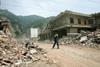
An international group of engineers is working on a plan to use satellite images to measure the damage to buildings caused by the earthquake in China last May
The Earthquake Engineering Field Investigation Team (EEFIT), together with experts from Europe and the US, has asked engineers to examine pictures from before and after the Sichuan earthquake and assess the damage caused.
If the technique works, it is hoped it could be used to speed up aid to devastated areas by allowing remote damage assessments of areas where access is still difficult.
Tiziana Rossetto, lecturer in earthquake engineering at University College London and member of EEFIT, said: “We couldn’t get to some areas as they were cut off by landslides. We are looking at how useful satellite imagery could be in assessing the extent of the damage. “If it does work, hopefully we can take it forward.”
The news comes as the Chinese government announced tighter construction standards for schools in response to public anger over student deaths in Sichuan.
More than 14,000 schools were damaged in the earthquake and a government report last month admitted that 2.5% of China’s schools were poorly built.


No comments yet