


With so much information and so many experts, it becomes very difficult for the masterplanner to control and visualise what the final scheme will look like. In fact, the scheme's future residents and workers often find visualising their future environment all but impossible.
And there is another problem: because of the number of disciplines involved, changing and adapting the design can be laborious. The effort needed to produce just one plan is considerable, and the exploration of alternative and contingency scenarios are usually limited to a few tweaks to the existing design. The scheme is pretty much set in stone right from the first draft.
But all that is about to change. Multidisciplinary designer B Consultants has developed a computer-based masterplanning system that is powerful enough to allow whole cities to be laid out at the touch of a few buttons. The software is a more realistic version of Sim City: within seconds, the expertise of dozens of professions can be processed, synthesised and evaluated.
If the planners want a closer look at the city, the program will allow them to take a stroll along the city's virtual streets to see how the layout works and feels from a pedestrian's perspective. And once they get tired slogging through the city on foot, one flick of the joystick will have them flying over the city for a bird's eye view.
With this program, the planner is given the powers of a god. At the touch of a button, an office building becomes apartments, and information on how that affects rents, land values and water consumption in the area is immediately available. A click of a mouse can move an underused bus stop to a busier street. Another twitch and a factory is moved away from parkland. Individual disciplines have always been able to calculate different aspects of these changes, but this software allows all the effects of any change to be seen at once.
"Whereas each profession has its own software tools, it seemed unbelievable that there was no computer program capable of co-ordinating the information from the eight or so planning consultants sitting around the table," says Graeme Jennings, director of architectural applications at B Consultants.
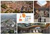
The approach is being used for the first time in conjunction with architect Zaha Hadid's studio to masterplan a 180 ha high-tech city on the outskirts of Singapore for developer the JTC Corporation. B Consultants first got involved in the project as part of the Richard Rogers Partnership's competition entry, but was invited to join Hadid's team when it won.
The program distils the input of the consultants into eight key factors, each represented on a different Excel spreadsheet: cost, open space, density, building height and plot ratio (or "massing" in planningspeak), water use, public transport accessibility and energy use. "From a raft of parameters you have to pick out the key information on each and download that on to a spreadsheet," says Jennings.
Because the program links each of the eight variables, changing one will have an impact on all the others. For example, if the client changes the plot ratio, the program will give a revised readout for energy use over a 24-hour period. The real power of the software is that it then transforms this spreadsheet into a 3D axonometric model of the city, complete with buildings represented by a series of rectangular blocks. The colour of each block indicates the building's primary use. By "dragging and dropping", the buildings can be moved around the city.
But the real beauty of the program is that it will allow designers, developers and members of the public, to wander through their virtual city to get a pedestrian's impression of how it would feel – which Jennings says is a world first.
B Consultants adapted the graphics program from the Quake III computer game to power the "V/SpaceLAB" walkthrough module.
To keep the amount of computing power to a minimum, buildings are simply represented as large blocks of colour, without much detail. "This means that a developer could sit at home and walk around their project on their child's Playstation; or, by using the internet, share the experience with up to 64 other people," says Jennings. And because the walkthrough can be projected on to a wall, the whole design team can be sat around the table discussing how well aspects of the plan appear to work.
The speed with which a walkthrough can be created will allow the planning team to explore the scheme even as the design is changing. "Rather then spending thousands on creating a sophisticated walkthrough model, planners can spend hundreds of pounds creating several mini-models," says Jennings. He admits, however, that more investment is needed to further refine the software before general release. "The software might be taken on by a software developer to refine it further to produce 'a shrink-wrapped product' suitable for all users."
For now the team is putting the final few tweaks to the Singapore scheme. Then the software will be put to the test on a regeneration project closer to home: the London Borough of Newham are going to use it in a study to assess the Canning Town masterplan.
While it is the development team that stands to benefit from use of the software in Singapore, the software's 3D modelling should really come into its own when it comes to explaining schemes, such as the Canning Town scheme, to the community. Its 3D graphics and walkthroughs might even help communities get involved in the masterplanning process, as is encouraged by Lord Falconer's planning green paper.
For now, the visualisation software will be used as part of the Game On exhibition, scheduled for May at the Barbican Centre in London. Here visitors can fly through landscapes created by artists and B Consultants, just by flicking a joystick. Who knows? Maybe the public will take to masterplanning their very own cities – then living in them in their spare time.


No comments yet