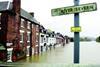
The picturesque town of Bewdley made the headlines in 2000 after it suffered three floods in six weeks. The challenge was to stop it happening again, but every option was either impossible, could make things worse or would cost £470m. Except for one …
Bewdley is the epitome of Rural England. Situated on the gently rising banks of the River Severn in Worcestershire, the charming Georgian town, clustered round Thomas Telford's elegant sandstone bridge, was once a prosperous pewter-making centre. Today, its wealth is derived from the hordes of tourists that come to rummage through the jumble of antique stores and eat scones in its riverside teashops.

But this scene is a fragile one, as residents will testify. In the autumn of 2000, the town looked far from idyllic when it suffered its worst flooding for more than 50 years. The Severn surged 5.6 m above its summer level after torrential rains in the Welsh mountains. Hundreds of properties were under several feet of water, non-amphibious traffic was halted and town brought to a standstill. Then, in the space of six weeks it happened again. And again. The town ended up in the national headlines, as the scenes of devastation were repeated – each flood ruining clean-up operations from the previous one. The floods, which have become more frequent and more serious in recent years, also caused the partial collapse of the town's river wall.

Work on finding a solution began almost as soon as the residents had finished mopping their homes for the third time. The Environment Agency, the public body responsible for managing rivers in England and Wales, considered a variety of options to prevent the flood's recurrence. The easiest way would have been to increase the height of the river walls, but to cope with the next flood these would have to be almost 3 m higher – effectively obscuring the view of the waterway from the town and ruining its tourist trade. Clearly, another solution was needed – and quick – if the town was to be spared further acts of God.

In May 2001, the agency investigated a variety of solutions. These included the possibility of storing floodwater upstream during a flood and then releasing it under controlled conditions after the threat had gone. But both the catchments for the Llyn Clywedog reservoir and Lake Vyrnwy were too far upstream to have any effect on the river levels at Bewdley, so that idea was abandoned. Another approach was to to increase the floodplain area immediately above the town to boost its storage capacity, but that was also unfeasible. To be effective, the more than 40 km of riverbank would have had to be heightened and large areas of farmland and some homes would have been flooded for long periods under a huge lake. Even a dam was considered for the steep-sided gorge just upstream of the town, but that would have caused similar problems.

The agency tried a different approach: rather than storing the floodwater why not increase the capacity of the river? First of all, dredging was considered. But to accommodate the type of flood the town experienced in 2000, the the river would have to be 3 m deeper. This would have involved blasting out the rocky riverbed as far downstream as Worcester, 30 km away. Not only that, but all the bridges and other waterside structures would need to be reconstructed and their foundation depths increased to cope with the change – making this an expensive solution both financially and environmentally.

This extreme solution was not the dearest. The most costly, and perhaps most innovative, was to construct a series of bypass tunnels beneath the town. When the calculations were done, it became clear that the volume of water would have required half a dozen 7.6 m diameter tunnels – each the size of the Channel Tunnel – at an estimated cost of £470m. However, the hydrological model showed that even this level of investment would not have prevented flooding in Bewdley because water would have backed up to the town from the point downstream where the tunnels rejoin the river.

In desperation, the Environment Agency decided to trial a revolutionary German demountable flood barrier, known as the Bauer system, for the first time in the UK. Because it is demountable, the 186 m long barrier would spend most of the year stacked on pallets in a warehouse away from the town. The only clue to its existence would be a series of stainless steel plates, set 3 m apart on the access road adjacent to the river wall, to provide the anchor points for the barrier.

Work started on the barrier's installation in December 2001. Ten months later, and the Environment Agency's operatives are starting to familiarise themselves with its operation, ready for this autumn's floods.

When a flood alert is given, Environment Agency's staff will truck the barrier to site as a kit of parts. First a series of 2.8 m high I-section aluminium posts will be installed. These are bolted to the aluminium base plates to form a string of posts 3 m apart along the riverbank. Next, aluminium planks are slotted between the posts to form the flood barrier. The planks are approximately 300 mm high, so they can be added individually up to a maximum height of 2.7 m, depending on the expected height of the flood waters. Roger Prestwood, project manager of the Environment Agency, says: "The system should only take a few hours to assemble."

Apart from the mounting plates, there is no evidence of the barrier when it is not in use.

The barrier butts up to – but does not touch – Telford's listed bridge at its southern end, where a special seal will fill the gap between the barrier and the bridge abutment. At its northern end, where the land rises to a car park and the views are less rewarding, the barrier finishes at a short section of newly constructed wall.

The shiny metal barrier is just part of the £2m flood prevention system; another critical element was the below-ground works. In Germany, where the system has been installed on the broad banks of the rivers Oder and Mosel, the barrier's foundations have been constructed from large interlocking piles that effectively form a concrete wall below ground. The piles support the metal barrier and, more critically, provide an obstacle to floodwater streaming through the permeable ground beneath the barrier.

The combination of a narrow access road, the proximity of ancient properties close to the river, a weak river wall and a mass of buried service cables and sewers meant large diameter piles were unsuitable for Bewdley. Instead, contractor Birse, working with consultant engineer FaberMaunsell, developed a solution based on interlocking bored mini-piles and raking piles extending down into the sandstone bedrock. These form a hydraulic cut-off and provide additional support to the existing river wall (see "Supporting cast", right).

Creating this underground barrier between the river and the land might exclude floodwater, but it would also prevent groundwater draining into the river. To circumvent this, a new storm drain and pumping station installation has been constructed. This will pump water from the land through the cut-off barrier and into the river.

Ten months after work first started, the scheme on Severnside north is nearing completion – and will be finished in time for this autumn's rains. Phase two, which will protect the town lying downstream from the bridge, is to commence next year.

However, work on the opposite bank of the river will not be taking place. The accounting system used by the Environment Agency calls for it to spend funds "to best effect", according to Prestwood. This means funds can only be spent where most benefit can be gained. "If a scheme does not meet the benefit/cost criteria, it cannot go ahead," says Roger Prestwood. Both schemes for the west bank of the town meet the funding criteria. However, as the east bank is less densely populated, the agency claims it cannot justify flood prevention schemes to protect it. Unfortunately for the residents living there, this will create a situation where those on the west bank will be able to peer over their newly installed flood defence at the devastated homes of their east bank neighbours.

Supporting cast: How the foundations work

The success of the scheme will depend on the integrity of the barrier’s buried foundations. “The Bauer system is normally erected on large-diameter interlocked bored piles,” explains structural engineer Kevin James, principal engineer at consultant FaberMaunsell. These piles support the metal barrier and, more critically, provide an obstacle to prevent floodwater streaming through the permeable ground beneath the barrier. “The main part of the job is the design of the underground cut-off,” says Environment Agency’s Roger Prestwood. But the combination of a narrow access road, the proximity of ancient properties close to the river, a weak river wall and a mass of buried service cables and sewers meant large-diameter piles were unsuitable for Bewdley. There was no obvious solution. Added to that, for the demountable barrier to be effective, its foundations would have to be constructed to a tolerance of 5 mm over its 186 m length. When the Environment Agency issued a design-and-build tender for the flood defence works based on the demountable flood defence system, the documentation did not specify how the crucial underground works were to be constructed. Instead, the most critical part of the scheme’s design was left to the contractor. Contractor Birse teamed up with consultant FaberMaunsell to bid for the works. “I was given the tender proposal and told to ‘take that, go out on site and come up with a solution to give the partnership a commercial edge’,” recalls FaberMaunsell’s James. “Developing a suitable solution that incorporated an underground cut-off wall to control groundwater and foundations to support the demountable barrier was complicated by the presence of congested buried services and the proximity of the ancient and historic properties next to the river,” says James. Together, contractor and engineer came up with a solution: to use the smaller diameter mini-piles for the construction of the cut-off wall and its support (see diagram above). The Environment Agency was suitably impressed and Birse won the contract. The design features a cut-off constructed entirely from interlocking mini-piles. This wall extends from a capping beam at ground level down into the sandstone bedrock 11 m below. The cut-off wall is stabilised by cast insitu reinforced concrete raking piles every 3 m. These act in tension when river level is low, holding the river wall in place. In a flood, when the barrier is up, the stress is reversed and the raking piles act in compression. The raking piles are connected to the capping beam by projecting reinforced-concrete link beams. The advantage of this design is that where buried services would normally have prevented the contractor installing a raking pile, the link beam’s length could be extended to provide the off-set necessary for clearance, or to allow the angle of the ranking pile to be varied. “We were never entirely sure where the sewer was,” explains James. More importantly, the use of mini-piles avoided the need for any heavy equipment on the riverside and reduced the vibration and disturbance to the adjacent historic buildings – and, most importantly, ensured that the teacups did not rattle in the Merchants Tea Rooms.