


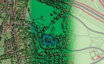
Infoterra has launched the GeoStore service to enable property developers and designers to carry out initial and rapid site surveys from their desks.
The service goes beyond the traditional aerial imagery and maps with a terrain model which can be complemented with height data of surrounding buildings to avoid potential line-of-sight planning objections. Developers enter the post code, grid reference or place name of any location in England.
A map, aerial photo and height data of a specified size can be ordered for immediate download straight to the desktop. The information can be read on a CAD or a GIS system for an in-depth visualisation of development plans.
Infoterra
Topics
Specifier 22 February 2008
- 1
- 2
- 3
- 4
- 5
- 6
- 7
 Currently
reading
Currently
reading
Rapid site surveys
- 9
- 10
- 11
- 12
- 13
- 14


No comments yet